
Drives and Hikes |
|
HALEAKALA NATIONAL PARK
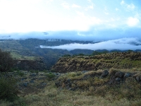
Haleakala crater, the top of the volcano, is easily reached by car. Lots of people like to go up for the sunrise on the first day here because they go to bed early and wake up at 3am due to the time change. Just 2 of the trails: HALEMAUU TRAIL (0.7 - 10 Miles)
7 Sacred Pools Waimoku Falls hike (see road to Hana) Uphill from the pools at `Ohe`o, there are two major waterfalls, beautiful pools, and a bamboo forest. Directly across the HANA HWY. from the visitor center's unpaved parking area you will see a break in the fence. This is the trail head. The first uphill leg should be made earlier in the day. Walk up through the pasture, keeping `Ohe`o Stream on your right. At a point 800 paces from the trail head, the trail forks. The right fork is a short path to the lip of 200'/61m Makahiku Falls. Further on, back on the main trail, the trail will drop sharply to cross Palikea Stream, but never attempt it unless stepping stones are exposed. The swollen, slippery stream can be swift enough to sweep the unwary over the edge of two waterfalls into a deep pool just ten yards downstream. As tempting as it looks to jump in on a calm, hot day, recent submerged rockslides could present a danger. Right after crossing the stream, one of the largest mango trees in Hawaii will be immediately on the left. The trail continues past ripening coffee beans and taro patches. Pass through a bamboo forest on a raised wooden walkway to keep from sinking in the mud. As you leave the bamboo forest, a glimpse of 400'/122m Waimoku Falls lays ahead. Another 300 paces to a fork the stream joins another on its left. Cross the left hand stream and follow the right hand stream about 250 paces beyond the fork to Waimoku Falls, its waters taking the long plunge down the face of a horseshoe-shaped cliff into a shallow pool at its base. Hikers are welcome to cool off, but are cautioned never to pollute the waters with soaps or shampoos. The Waimoku Falls hike is a four mile round trip; 2 hours up, and an hour and a half down. Bring water! The Waimoku Falls hike is lead by park rangers, free of charge, on Saturdays, but if you'd like to go it alone, pick up a trail map at the visitor center Nakalele blow hole This spot has a blow hole, tide pools, lava formations and crashing surf. It's about a 1200 foot hike to the blow hole along a clearly defined path. The island of Molokai can be seen across the channel. Take route 30 north from Lahaina. In about 45 minutes the road will become route 34 after the village of Honokahau. Nakalele Point is the most northern point Maui. It is located just past mile marker 38. You can't miss the parking area, scattered across the field are numerous "cairns" or rocks piled by visitors along with natural rock formations. The blowhole is created when the pounding surf undercuts and wears away a shoreline lava shelf. A hole in the lava shelf causes a geyser-like effect which can reach over 100 feet when air and water are forced upwards through the hole. While it may seen tempting to approach the blowhole for a great photo opportunity, don't do it. People have been killed as they get sucked back into the hole by the retreating water at this and other blowholes in Hawaii. La Perouse Bay Drive south from Kihei to the end of the road to see ruins of an Hawaiian village and lava flows, Maui's Haleakala is considered active because the last eruptions were only about 300 years ago and are likely to occur again. The Road to Hana Takes an entire day. Don't hike to water falls there are plenty you can see from the road. Must sees are Waianapanapa parks black sand beach and the beach cave, the 7 sacred pools, and Charles Linburg's grave. drive the back road home. It will take you through Kula then turn to Makawao and have dinner at Poli's Mexican restaurant (reservations recommended). IAO VALLEY
|